Publicité
An ecological paradigm-shift essential to stop the nightmare of flooding
Par

Partager cet article
An ecological paradigm-shift essential to stop the nightmare of flooding
Despites billions invested in water drainage projects each year, more and more places in Mauritius are facing flash floods in the context of the unprecedented Ecological crisis we are in. This trend will continue as long as governments in power do not understand that sustainable development is intrinsically synonymous with reaching harmony with Nature. This implies respect for natural ecosystems, and a radical paradigm-shift in the way the economy and democracy are designed. In a nutshell this is the transition proposed by the eco-socialism ideology we are rooting for at Rezistans ek Alternativ.
A resident from Mare d’Albert stated that more than 20 years ago, the Plaine Magnien wetland was starting just behind the football pitch and there were no sugar cane fields in the wetland area at that time.

This wetland system has been initially disrupted by sugar cane fields. However the core of the wetland has not been backfilled. Impacts of the sugar cane industry on wetland systems is a major concern in Mauritius. The Pointe d’Esny Lakeside project is an interesting use case, having some ESA wetlands separated from the Pointe d’Esny Ramsar site by sugar cane fields.

The picture above shows sugar cane fields between the Pointe d’Esny Ramsar site and the Environmentally Sensitive Areas (ESAs) wetlands 116, 117, 118 and 119. Presence of specific grass indicates permanence of water in the area, a clear scientific proof of wetland area disrupted by the sugar cane fields.
The point made here is the fact that this area is partly covered by sugar cane fields does not mean an absence of wetland.

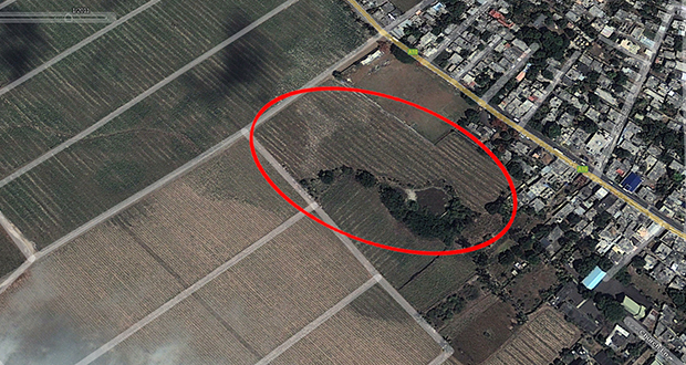
Satellite imagery above shows fallow fields in the Plaine Magnien wetland area in May 2019. The Plaine Magnien wetland system might have been healthiest during this period, because of the absence of human alteration of the topsoil.
Wetland restoration is a critical goal in order to face the unprecedented Ecological crisis we are in, as wetland systems are amongst the most efficient natural ecosystems to mitigate flooding. In 2009, an ambitious study focusing on Environmentally Sensitive Areas, amongst which wetlands, was carried out using public funds. This study has not been released in the public domain by any government since 2009. Rezistans ek Alternativ leaked this study a few years ago for the sake of public interest, which is available at https://esabillnow.org
In summary, we find that urbanisation is the major threat to lowland wetlands in Mauritius. More than half of the wetlands (60%) have been obviously fragmented, mostly as a result of extensive land development. Backfilling of wetlands is an enormous problem in Mauritius, affecting 90% of all Wetlands. We found that 105 wetlands have at least 90% of their border disturbed whereas only 11 can be considered intact with less than 10% edge disturbance.
<p> </p>
<p align="center">Extracts of the ESA 2009 study findings</p>
A wetland area is dynamic- smaller during dry periods, and wider during rainy periods. Our laws and regulations do not integrate these basic natural principles. Determining the wetland system area should consider the maximum area reached during rainy periods, and not the smaller area of dry periods. This is why for the wetland system to function correctly its vicinity should not be disrupted.

Satellite imagery shows the Plaine Magnien SME Park construction near/in the wetland area in November 2021.
Currently, even with the Environment Protection Act (EPA) and the Environment Impact Assessment (EIA) process, Mauritius wetlands are not adequately protected from urbanization. Even the Wetland Bill draft in the government pipeline, and the EPA revision already prepared by the government in office do not genuinely address the multiple threats our wetlands are facing.
In EPA section 28, a public department initiating an undertaking can be exempted from an EIA License by the Minister of Environment, but does not save them to submit the undertaking EIA. This bad practice has been inherited from colonial times, where the Power was of divine right, and did not have to seek any authorisation to proceed. This colonial bug present in the Common law, should have been thrashed out from our legislature since our independence.


In Les Salines Black River, a road has been constructed in the salt marsh in the vicinity of the ESA wetland 76, without any EIA License. None of the Impacts of road on the ESA 76 wetland system, and its fauna and flora have been assessed.
Unfortunately having an EIA license is not sufficient to protect a wetland system. NMH Les Saline PDS EIA and Pointe d’Esny Lakeside EIA are two examples where EIA licenses have been emitted, while impacted wetlands are in danger of disruption. Public bodies should be free from political interference, and money politics. Moreover public officers should be sufficiently equipped to be able to challenge the EIA outputs and not take them for granted, as well as having the sufficient independence which is not the case.
Plaine Magnien inhabitants mentioned that water floods started after the heavy rains stopped. While this remains a mystery for some, it can be related to underground water flows rising to the surface, causing the floods. One hypothesis could be that underground water flows in the vicinity were usually rising out in the Plaine Magnien wetland. But because of its backfilling, underground water flows coming from upland might have been rising elsewhere, and unfortunately in the houses of the village inhabitants.
Geotechnical and Geophysical surveys should be carried out for big urbanization projects to map the underground cavities and underlying water flows, in order to proceed with impact analysis.
For example, in the Pointe d’Esny Lakeside EIA, a geophysical survey has been carried out to map potential cavities down to depths of 15 meters. This type of survey can indicate how the wetlands water flows in.


In the case of Pointe d’Esny, the cavities also connect from a water flow perspective the ESA wetlands 116, 117, 118 and 119 to the Pointe d’Esny Ramsar site a few thousands meters north. This should be a sufficient reason not to grant the EIA License.


Villages having potential water floods coming from upland are not protected in the absence of proper buffer areas. Sugar cane fields and roads can have an amplification effect on flooding, because of soil impermeability and mud effect increasing the force of water coming from upland.
In the case of Plaine Magnien, a proper buffer area could consist of forests and wetland areas in the vicinity of the village. Moreover underground water flows need to be identified using Geotechnical and Geophysical surveys as seen above, and connection restored to these buffer areas.

The elevation data above is approximative. In 2018, a Digital Elevation Model (DEM) mapping of the Republic of Mauritius was initiated, using public funds. Still in 2022, this study has not been placed in public domain despite being of public interest.

This Digital Elevation Model (DEM) is a key data to craft flooding mitigation policies in the context of the Ecological Crisis we are in. It can be used to identify houses that can be flooded, implement some inhabitants relocation policies, and avoid building in areas that can be flooded.
Placed in the public domain, all the people of Mauritius would be able to create some innovative tools and frameworks to address the unprecedented challenges facing us. However, as for the ESA Study 2009, this study also has not been placed in the public domain. Recently, during the celebration of Earth Day 2021, Rezistans ek Alternativ renewed its open call for the Digital Elevation Model to be placed in the public domain (https://earthday.alternativ.mu) following the invitation from the Minister of Environment to submit proposals related to Environment Protection Act (EPA) review.
Any citizens having a copy of the Digital Elevation Model (DEM) is encouraged to send it to Rezistans ek Alternativ, in order for us to leak it in the name of public interest.
The worst is that big corporations and oligarchs have access to such information, as it is the case for the ESA 2009 Study, for them to craft their EIA applications, or the Digital Elevation Model (DEM) to be able to carefully select the lands they speculate on, leaving the flood-prone lands to the working-class. Climate injustice also starts here.
This unacceptable political line of complete lack of public interest and inclusiveness is however coherent with the way this government handles the environmental issues. Few years back, the Minister of Environment setup his “Assise de l'environnement” where only big corporations and some conservative NGOs were invited. No fishermen, no planters, no ecological activists, no locally elected representatives, no unionists took part in this conservative environmental hijack.
After the floods in Plaine Magnien in April 2022, a meeting was held on the 6th of April 2022 with the participation of two Ministers of the Constituency in the Citizen Advice Bureau (CAB) of the locality, without inviting locally elected representatives. The Politically motivated arrests that followed is a pure democratic disgrace, in the same anti-democratic line of the government in power.
The Ecological Crisis is such a tremendous challenge to address that all the People of the Republic of Mauritius should be deeply part of it. We believe that Rezistans ek Alternativ has paved the way forward as we succeeded to federate an unprecedented horizontal mobilisation to face the Wakashio oil spill, and such an eco-socialist open-approach is a must-have to face the Ecological Crisis.


In the past, we made repeated calls for this amazing natural heritage to be declared as a ‘Bien Commun, inaliénable et imprescriptible’, and a Ramsar site of international importance. The inhabitants of the region, guardians of this ecological tresor, would pioneer a sustainable form of eco-tourism as eco-guides and tenants of low foot-print eco-lodges.
Incorporated in April 2021 during the hard times of the Covid-19 pandemic, PR Capital (Mauritius) shareholders are Julien Ridon and Christophe Petit, both from a French real estate company named Groupe CITY (ex FIDUCIM) having as Mauritian director Jason Harel.
Why don't capitalists give Nature a break ? After a hotel project in the Blue Bay Ramsar site, an hotel in a dune system at La Cambuse, a planned hotel in a wetland at Les Salines Black-River, proposed villas in Pointe d’Esny and Belle Ombre wetland systems, and the Pomponette coastline to name a few, we need to end these ecocides.
As everywhere else, the natural heritage grabbing and disruption planned in Roche Noires also brings gentrification to the locality and will negatively impact the livelihood of the Roches Noires village.
Who is in to defend the Rights of Nature?
David Sauvage
Rezistans ek Alternativ
Publicité
Publicité
Les plus récents